Spaced Experience | Final Jury!

Based on the previous critics, I first rearranged my field. I took advantage of 3DCS. My field had a different void, one of which was more introverted and the other was more extroverted. And the spaces I would create in these voids are contrasting with each other. Where my voids were more introverted, my spaces were less, and my voids were more extroverted, and my spaces were more dense and continuous. On the other hand, fewer spaces, I broke continuity because of the level difference, because I wanted people to have different experiences on both sides.


Here is my final poster:

final poster son

Spaced Experience | Pre-Jury!

First, there are 2 different gaps in my field, dense and less dense voids. The strategy I determined by looking at my field was contrast. According to contrast, I have fewer spaces in my dense voids, while the number of spaces in my less dense voids is numerous. At the same time, I made a transition part in connecting these spaces.

However, where people have a lot of spaces, thanks to different directions and scales ramps, they can experience every space there. On the other hand, people cannot experience every space because there is a lot of level difference where there are little spaces.
pre jury 5pre jury diagram

The Field | Phase 01 | Pre-Jury!

In Phase 1, I mentioned the production stage of this field. This time I had to turn the voids in this field into a meaningful spatial space by adding new elements. To do this, first I had to find a strategy and some tactics that showed this strategy.

The strategy was to provide inter-voids diversity. First, I wanted to create a variation between the voids in the different directions and in different scales by using the tearing-folding process and the intersection process. Because, first, the layers in my 3-dimensional model contained intersecting variations of information. And my strategy should be in parallel with the method I applied in my map.


prej1prej2prej3

The Field | Phase 01

I mentioned a field trip in my previous writings. And at the end of this field trip, I explained that I made a map of a total of 20 layers including information about that area.

This time they asked us for a 3-dimensional composition of sections 4 different maps with our own map. I tried not to lose the information on the maps as much as I could in making this composition, and when each map physically intersected, at least 2 information on those maps were intersecting and defining. That was my strategy.

In this composition, I first determined the compatibility of the information on each map and then combined it. For example, I combined information on how wind density in changing distances in the city changed in one of the maps, away from the viewing of distances city on the other map. What I was thinking about here was that while the wind power in the region close to the city was very high, the wind strength declined as it moved away from the city.

Arch102_thefield_phase2_bensuacarakcay_map.jpg3


After this intersection of different maps, they asked the topography of this composition. What they want to be aware of is that the topography will not physically similar to our map composition, but that we will use the information in the map composition in our topography.

While we are doing the topography, we only want to tear and fold and intersect as operation. They also asked us not to use the utility knife, cut with the help of hand and finger while doing this topography. I think the reason they wanted it was to increase the natural appearance of the topography. What I did in this topography was to show that the information in the 4 divided areas was unified. Therefore, I used the information in my map instead of the parts created as a result of the folding operation in my topography, and I showed the information intersections on the maps by the relations of these parts with each other.

Arch102_thefield_phase2_bensuacarakcay2

Field Trip | BERGAMA | Analysis

bergaama

As the whole studio, the city that we were going to study was Pergamon Acropolis. We observed the experience of the place with all the physical properties, analyzed their effects, and documented all the results as multi-layered maps, freehand section drawings, sketches, photographs and etc.

Then I recorded all my observation and interpretation in 20 multi-layered maps (but I could only do 16), which are expected to be abstract documentation of the place in a diagrammatic language, and assisted by free-hand sections, sketches, keywords, and short notes.

Bergama

The only thing I had a hard time here was that there wasn’t a certain area in the city, so the places that used to be a place that used to be a place now contain only the remains of stone, so I tried to prepare a map with no borders when it could be.

It was very fun we have spent the weekend in order to prepare 20 layered maps ( but I could only do 16 again) that each layer of it focuses on a different quality, but when they are overlapped they are actually a whole. Layers are highly related to each other.

IMG_3416

Field Trip | BERGAMA

If you ask me, the most beautiful assignments of this period will begin after this trip. Generally, the purpose of field trips is to analyze the area and to design spaces according to these analyses. First, the area to be analyzed was determined. We were going to visit the ancient city of Bergama. First of all, we were asked to do short research about this ancient city in Bergama and to create a poster of our research.

Arch102_2018S_SP03_bensuacarakcay

After this research, we set off and when we got there we had the opportunity to take photographs of some important buildings in different parts of the ancient city and also in Bergama.

PERGAMON ACROPOLIS


RED BASILICA

You may want to click on the link to learn about this structure. https://en.wikipedia.org/wiki/Red_Basilica


BERGAMA CULTURAL CENTRE | EAA – Emre Arolat Architecture

https://www.archdaily.com/901652/bergama-cultural-center-emre-arolat-architects

Spatial Analysis

As I mentioned in my previous postings, we were asked to analyze the buildings we investigated with the themes taught at the beginning of the lesson. In order to do these analyses, I needed building plans, these sections and some interior and exterior photographs of these buildings. In line with the completed analyzes, we determined a specific theme for each building and made abstract models according to the themes we have determined our buildings.

Arch102_2018S_Ass01_Phase2_bensuacarakcay


Arch102_2018S_Ass01_Phase2_bensuacarakcay2


Arch102_2018S_Ass01_Phase2_bensuacarakcay3


Arch102_2018S_Ass01_Phase2_bensuacarakcay4

When I talked about the themes I applied to the buildings I selected, I thought that they should be in accordance with the 3 buildings I chose and I refer to the plans of the buildings with the other options.

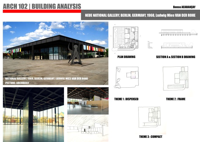
THEME OF DISPERSED ( Referencing of Neue National Gallery)

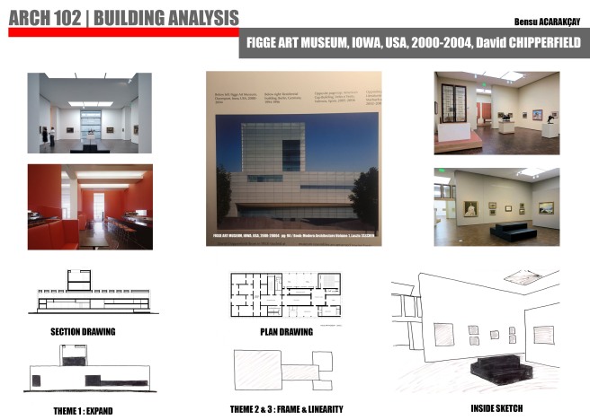
THEME OF FRAMING ( Referencing of Figge Art Museum)


THEME OF PROMENADE (Referencing of Montreal Biosphere)

What is the meaning of space?

We have begun to process the subject of space in this term and I think we have entered the beginning of architectural design because, In my opinion, every structure on the world shows a space and the spaces that are shown, how different experiences are offered to people, we are starting to find the answer to this question.

First, we found a building from the list I mentioned in my previous post and 3 different themes to define the places in this building. Besides, we were asked to research 3 more buildings outside this building. I have chosen 3 buildings with a spatial potential using the architectural resources in my library as much as I can.


The building I selected from the list: Neue National Gallery / Ludwig Mies Van Der Rohe

stringio

3 other buildings I found from library resources:

Figge Art Museum, USA / David Chipperfield

1200px-Figge_Art_Museum_2


Montreal Biosphere, Canada / Buckminster Fuller

Rodrigo_Maia

Walt Disney Concert Hall, California / Frank O. Gehry

Gehry_PhilippRuemmele_riotphotography.com


Where we were?

Yes, we started to make an introduction to architectural design and the first subject of this course was SPACE. What is space, when we create the space, we started to find answers to the questions of how we can get an experience there?

To do this, we were first given some spatial themes, and we were asked to choose a building and at least 3 themes to describe its location from the list below.

themes

That’s all for now. To be continued… 🙂